


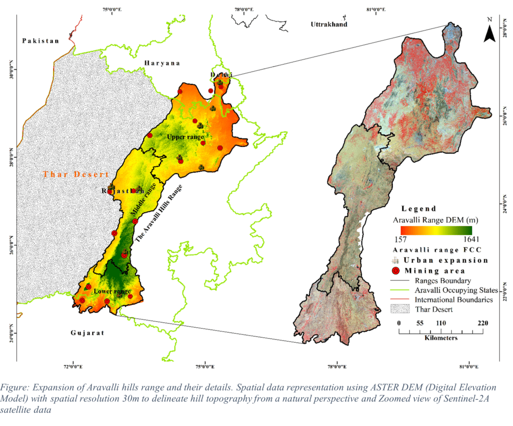
The story of the Aravalli Range is more than just the story of a mountain range; it is also the story of how India’s deep geological past is shaping its environmental future. The Aravallis were silent witnesses to the making of the Indian landmass long before the Himalayas rose. The Aravalli Range is one of the oldest mountain systems in the world, having formed between 1.5 and 2.6 billion years ago, during the Precambrian Era. They have been weathered, changed, and stabilised over millions of years, but they still do important functions necessary for life to continue in northwestern India. The Sanskrit word Ara means ‘peak’, and Valli means ‘line’. This is where the name Aravalli comes from. It means, a line (or chain) of peaks. It perfectly describes the Aravalli Range, a long, linear mountain range that runs about 800 kilometres across western and northern India, from Gujarat (Palanpur) to Delhi (Raisina Hills) through Rajasthan and Haryana.
The Aravalli Range is a natural ecological framework in one of India’s most climate-sensitive areas. The Aravallis are scientifically important in a country where the monsoon is becoming less reliable, people are becoming more dependent on groundwater, and land is becoming less fertile.
AN ANCIENT GEOLOGICAL SYSTEM
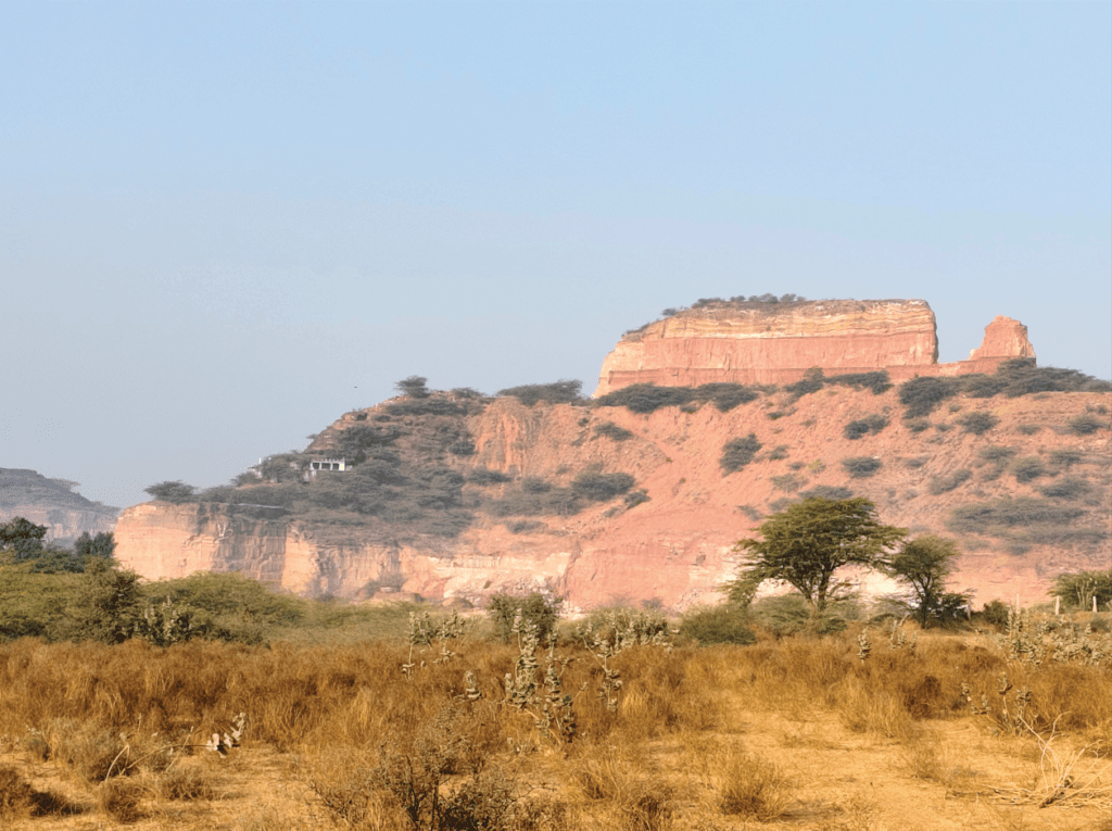
The Aravalli Range is one of the oldest fold mountains in the world, having formed more than 2.6 billion years ago. The Aravallis are not as young and tall as the Himalayas. Instead, they have been carved by years of erosion, which has left behind low hills, ridges, and valleys made mostly of dense metamorphic rocks. The Banded Gneissic Complex (BGC), which is mostly made up of gneiss and granite, is the base of the Aravalli system. It is about 3.2 to 2.5 billion years old. In an old ocean basin, massive layers of silt were laid down on top of this basement. During a large tectonic event, termed the Aravalli-Delhi Orogeny, these sediments were later squeezed and folded. This created what is now known as the Aravalli-Delhi Fold Belt. Quartzite (a durable, resistant rock that forms ridges), schist (metamorphosed sedimentary rocks), gneiss (high-grade metamorphic rocks), marble and silicate rocks, and volcanic and basic intrusive rocks are the most common types of rocks. Because of its geological structure, the area possesses many natural resources, like copper (Khetri belt), zinc and lead (Zawar belt), marble (Makrana), and granite and construction stone.
INDIA’S NATURAL BARRIER AGAINST DESERTIFICATION
The ranges are often called India’s natural barrier against desertification because they play an important role in keeping the Thar Desert from spreading eastward. The Aravallis block the flow of hot, sandy winds from the Thar Desert to the fertile plains of Haryana, Delhi, and western Uttar Pradesh. They stretch from the southwest to the northeast. The range isn’t particularly high today because it has been eroded for billions of years, but its ridge orientation and forest cover slow the wind, stabilise the soil, and keep desert sand from moving.
WATER SECURITY IN A SEMI-ARID LANDSCAPE
Groundwater is the main supply of water for farming and everyday consumption in many areas of Rajasthan, Haryana, and nearby areas. The Aravalli hills are essential for keeping this resource alive. During the monsoon, the ridge valley systems of the Aravallis work like natural catchments. Rainwater that flows down rocky quartzite hillsides is directed into seasonal streams, low spots, and traditional water collection structures like johads. These processes help the groundwater recharge in a landscape that is otherwise short on water. The mountain creates key watershed divisions that send water to both the desert basin and the Indo-Gangetic plains. Mining, deforestation, and infrastructure development have caused fragmentation, which has messed up natural drainage routes and recharge zones.
SUPPORTING BIODIVERSITY AND ECOLOGICAL BALANCE
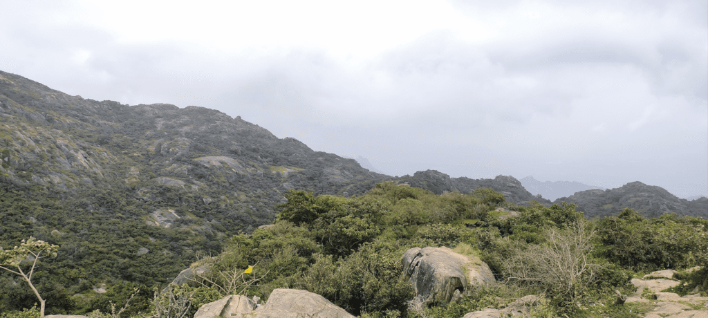
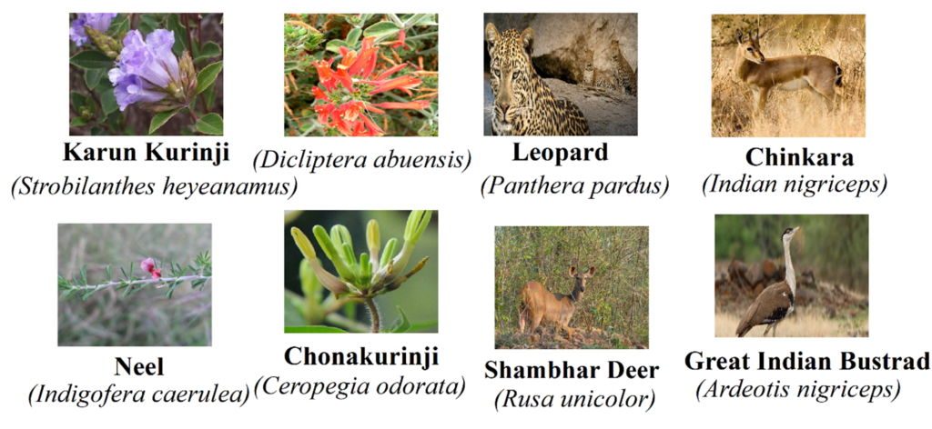
The ranges protect varied living forms by maintaining environmental balance and introducing new flora and animals to northwestern India. Although largely dry, there are dry deciduous forests, prickly brush, grasslands, and rocky places. Besides birds and reptiles, there are leopards, hyenas, jackals, and nilgai. The large, natural Aravalli route connects unpaved sections of Delhi, Haryana, and Rajasthan. This enables animal migration and DNA mixing more easily. Plants in this area manage the weather, keep the soil from washing away, and feed pollinators and seed dispersers to sustain the ecosystem. New roads, buildings, mining, and urbanisation damage habitats and disrupt ecosystems. To safeguard the ecology and animals, we have to rehabilitate and maintain the Aravalli.
CLIMATE REGULATION AND CARBON STORAGE
Northwest India relies on the ranges for climate regulation and carbon storage. Despite having fewer trees than humid mountain systems, its dry deciduous woods, thorn scrub, grasslands, and soil systems store carbon in a semi-arid setting. Plants absorb carbon dioxide from the air through photosynthesis, and soils and rocks retain organic carbon for a long period. The ridge orientation modifies wind direction, keeps Thar Desert dust from moving, and stabilises local microclimates by decreasing surface temperatures and holding more moisture. Timbering, mining, and land use change reduce above-ground biomass and soil carbon reserves. Restoring native species and conserving ridges helps biodiversity and the Aravalli’s climate change and regional stability.
EXPANDING MINING AND LANDSCAPE TRANSFORMATION
Mining in the Aravalli Range has grown and changed the environment during the previous two decades. Marble, granite, copper, zinc, and building stone are abundant in the range, causing quarrying in Rajasthan and Haryana. Open-cast mining has levelled ridge systems, shattered quartzite formations, and disrupted natural drainage channels that recharge groundwater in this semi-arid environment. Ecological repercussions go beyond scars. Removing hill slopes accelerates soil erosion, increases dust pollution, destroys wildlife habitats, and reduces the range’s climate buffer against the Thar Desert. Waterlogging and pollution from abandoned pits are common. Mining destroys ecological corridors, making it harder for species to travel and swap DNA. The Supreme Court of India has prohibited some illegal acts, but enforcement gaps and transitory policy changes make things tough.
Aravalli landscape transformation involves modifying an ancient geomorphological system, not only resource accumulation. Long-term ecological services are worth more than short-term economic benefits from mining minerals.
URBANISATION AND INCREASING PRESSURE
Rapid urbanisation, especially in the NCR, is straining the Aravalli Range. Growing cities like Gurugram, Faridabad, and Delhi have pushed infrastructure, real estate, roads, and utilities down into unstable ridge systems. Concrete landscapes now surround small sections of quartzite hills and scrub woodlands. This alters natural drainage systems, reduces groundwater recharge zones, and weakens the Aravalli’s dust and heat protection. Land development weakens slopes, increases runoff, and worsens the urban heat island effect. Population increase and infrastructural construction are stressing the Aravalli Delhi Ridge. Urbanisation alters the physical environment and reduces animal corridors and habitats in semi-arid ecosystems. Spatial expansion and ecological compression force natural systems to work in smaller spaces. Urban pressure might permanently harm the Aravalli’s ecological integrity and long-term resilience without science-based zoning, ridge protection, or severe land use laws.
THE ARAVALLI AS INDIA’S “NATURAL GREEN WALL”
Aravalli Ranges are called India’s ‘Natural Green Wall’ for their geomorphology and climate science characteristics. In western India, the Aravalli mountains extend diagonally from southwest to northeast. They slow down sand-filled winds, stabilise semi-arid soils, and support dry, deciduous, and thorny scrub habitats that absorb ecological shocks to stop the Thar Desert from migrating. In India’s most climate-sensitive region, its ridges affect wind patterns, its valleys recharge aquifers, and its vegetation stabilise the weather. Aravalli acts as natural climate defence infrastructure. The Indian government’s new ‘Green Wall’ restoration programme, which u ses linear afforestation goals and canopy extension measurements, does not match this old mountain range. Aravalli is not a barren desert waiting for trees. Shallow soils, stony quartzite outcrops, and open vegetation mosaics make it geologically complex. Dense plantation models, especially with non-native or water-hungry plants, can disrupt water balance and alter native grass and scrub growth. The problem is landscape fragmentation from mining, infrastructure, and urban growth, not a shortage of trees. To strengthen the Aravalli, we must protect ridges, restore watersheds, maintain natural corridors, and use land according to geology, not plantation mathematics. The Aravalli should remain a semi-arid mountain ecology rather than a homogeneous afforestation narrative, according to science.
GOVERNMENT INITIATIVES AND POLICY CONTEXT
There isn’t just one law that protects the Aravalli Range. Instead, a combination of national environmental laws, state notifications, and court orders provides protection. The Forest (Conservation) Act of 1980 and the Environment (Protection) Act of 1986 set the rules. The Supreme Court of India has been crucial in stopping illegal mining and protecting forests. Reserved forest status protects some parts of the range in Delhi. But different state policies and changes to the law over time have made enforcement uneven. Despite recognition of the Aravalli’s ecological importance, India still lacks a unified, interstate conservation authority or a clearly demarcated ecological boundary for its long-term protection.
THE LEGAL BATTLE FOR THE ARAVALLIS
Environmental groups sued Haryana and Rajasthan in the early 2000s for enabling unlawful mining in the Aravalli Range. The Supreme Court of India banned mining in sensitive Aravalli areas, especially south Haryana, in 2002. Later forest conservation litigation orders emphasised the necessity to safeguard the range from ecological degradation. The Court advised the government to conduct a scientific and long-term examination of new and renewed mining leases in 2024. Later dispute over elevation-based Aravallis legal border changes led to more judicial and expert evaluation. The court is still monitoring the situation and has stated that illicit mining must be stopped and that borders must be determined scientifically. The legal battle began with early 2000s mining bans and expanded into environmental cases. A broad ban on new leases and scientific mapping was issued in 2024. A controversial reinterpretation in 2025 made things worse. The fight is now headed toward scientific re-evaluation and court scrutiny.
CURRENT STATUS OF THE ARAVALLIS: A LANDSCAPE UNDER DIFFERENTIAL STRESS
The Aravalli Range is not equally threatened; instead, its weaknesses are different in its northern (upper), central (middle), and southern (lower) parts. The geography, economy, and closeness of cities all affect the way people put pressure on each zone.
UPPER ARAVALLI (HARYANA-DELHI STRETCH)
Land encroachment and urban expansion
Gurugram, Faridabad, and Delhi’s northernmost stretch is threatened by land invasion and real estate growth. Rapid urbanisation in the NCR has pushed farmhouses, residential communities, infrastructure corridors, and commercial buildings into unstable ridge systems. Encroachments often start as minor land use changes but eventually change hill slopes. Blocking natural drainage routes reduces groundwater recharge and ecological corridors. Despite court orders to prevent mining and protect the ridge, illegal constructions and confusing rules are harming it.
MIDDLE ARAVALLI (JAIPUR-AJMER-ALWAR BELT)
Mining and ridge fragmentation
Mining and quarrying affect the central Aravalli. Marble, granite, and other minerals are abundant in this area, therefore open-cast mining is common. Ridge cutting, blasting, and excavating have destroyed watersheds, wildlife habitats, and landforms. Dust pollution, unstable slopes, and abandoned pits have weakened ecosystems even when mining is lawful. Although vital to preventing desertification, this belt is under constant pressure to be mined.
LOWER ARAVALLI (UDAIPUR-MOUNT ABU-GUJARAT STRETCH)
Tourism and land-hotel nexus
Pressure in the southern part comes from tourism-induced terrain alterations, especially around picturesque areas like Mount Abu and the hills. Land use change on slopes and in forests has increased due to resorts, hotels, second houses, and their infrastructure. Tourism boosts the economy, but unchecked development, slope changes, and water extraction harm the ecosystem. The new land hotel connection could commercialise ecologically vulnerable highland regions, harming watersheds and biodiversity.
Pressures vary but are connected over the Aravalli. Encroachment, mining, and tourism-related land conversion occur in the north, middle, and south. Different sorts of degradation are the issue. We need appropriate legislative adjustments, tight ridge protection, and landscape governance to safeguard this old natural barrier.
NEED FOR A CO-ORDINATED INSTITUTIONAL MECHANISM
Governance of the Aravalli Range is divided between departments, legal systems, and state jurisdictions. Urban authorities organise land-use, forest departments protect areas, mining departments extract, and pollution control boards enforce environmental rules. These teams often work separately. Institutional fragmentation causes inconsistent enforcement, policy overlaps, and long-term ecological planning gaps. The range controls desertification, water safety, biodiversity, and climate, so we need a coordinated system of institutions between states immediately.
A dedicated Aravalli Conservation/Developmental Authority could bring policies into line, assure that boundaries are clearly marked, improve monitoring with advanced geospatial systems, and make sure that everyone is responsible for their actions. Without such an integrated mechanism, protection efforts will continue to be reactive and fragmented, which is not enough to protect one of India’s oldest and most important ecological systems.
ECO-SENSITIVE ZONE FOR ECOSYSTEM PROTECTION AND STABILITY
The Aravalli Range has fragile dry deciduous forests, scrub habitats, grasslands, and animal corridors. Mining, urban expansion, tourism infrastructure, and land use changes threaten these areas. Biodiversity loss threatens water security, soil stability, and climate resilience in semi-arid, sensitive landscapes. A legally designated Eco-Sensitive Zone (ESZ) in crucial portions of Aravalli would regulate forests, wildlife habitats, and ridge systems. This would limit big impact activities while permitting environment friendly livelihoods. Desertification is prevented by the Aravalli, which spans multiple states. An ESZ is desired and ecologically necessary for long-term environmental security in northwestern India.
WHAT SCIENCE INDICATES NEEDS TO BE DONE
Science clearly shows that protecting the Aravalli Range needs a unified, technology-driven approach to the landscape, not separate regulatory actions. To keep the landforms stable, ridge-to-valley protection must be guaranteed, native dryland ecosystems must be restored instead of promoting plantation models that aren’t advantageous for the environment, and wildlife corridors and watershed systems must be scientifically protected. It is just as important to use AI-based tools to create accurate digital elevation models, find ridge changes, map encroachments, and make sure that environmental and forest laws are followed as it is to use LiDAR-based drone surveys and high-resolution geospatial real-time monitoring. Regular remote sensing audits and ground-truthing can give you real-time proof that illegal mining, building without permission, and breaking land-use rules are going on. With clear legal boundaries and coordination between states, this kind of technology would change Aravalli governance from reactive litigation to proactive, science-based environmental management.
RELEVANCE FOR INDIA’S ENVIRONMENTAL FUTURE
Natural barriers like the Aravalli reduce dust storms, protect groundwater, cool cities, and house animals. Between the Thar Desert’s spreading sands and northern India’s rich plains, these hills maintain nature’s equilibrium daily despite record heat waves and unpredictable rain patterns. Without the Aravalli, northwestern India will have stronger desert winds, lower water levels, greater temperatures in Delhi, and fewer green spaces. This rocky hill structure supports millions of lives despite its modest appearance. It regulates weather, stabilises vulnerable soils, recharges aquifers, and links forests across states. The question is not whether the Aravalli is essential anymore, but whether we appreciate it over time. Caring for it today means ensuring future generations have clean water, a stable climate, and a safe environment. One of the oldest mountain ranges in the world, the Aravalli protects India’s environmental future.
*The writer is a distinguished researcher on the Aravallis and a professor of environmental science at Central University of Rajasthan, Ajmer. He is the lead author of the book, ‘India’s Natural Green Wall: The Aravallis Past, Present and Future Perspectives’.


