


Image Courtesy: Dialogue Earth
Climate change is a stark reality the mankind is facing at present and so is the increase in the frequency and magnitude of natural disasters and extreme weather events. As per the World Disaster Report 2022 (WDR), natural disasters cost economic losses worth nearly US$313 billion. Asia was found to be the most affected continent accounting for around 75% of such landslide incidences, with large numbers reported in the Indian Himalayan Region (IHR). The top ten countries affected by fatal landslides caused by anthropogenic interventions are located in Asia, and India accounts for 20% of such incidents (WDR 2022).
The IHR is known for disasters like earthquakes, landslides and glacial lake outburst floods (GLOF). While the earthquakes occur with a long recurrence period (normally over 30 years or more), a major earthquake event causes widespread loss to human life, livestock, property and infrastructure. Landslides may recur every year but their extent is limited. GLOF, on the other hand, like earthquakes are limited in recurrence but with global warming and rising temperatures leading to melting of glaciers, formation of supraglacial lakes and breaching of glacial lakes has been observed in the recent past. Some examples are the breach of Chorabari lake near Kedarnath in June 2013, Raunthi Gad/ Rishiganga floods of February 2021 in Uttarakhand, and the breach of south Lhonak lake in Sikkim in October 2023.
WDR also indicates that the natural disasters normally occur in an overlapping manner, i.e., a GLOF resulting in a flooding which in turn initiates toe erosion/ bank erosion of hill slopes and landslides, which as a spiralling effect, at times may result in landslide dams across valleys, and the failure of such temporary landslide created dams causes landslide locked outburst flood (LLOF) inflicting havoc in the downstream stretches.
THE VULNERABLE HIMALAYAS
A substantial part of the population in South Asian countries like India, Pakistan and Nepal lives in the Himalayan mountain ranges which eventually face regular landslide risks caused by a mix of human activities and natural events related to the terrain, geology, and climate. According to a 2011 study, the North-Western Himalayas witnessed around 51% of all landslides in India during the years 1800 to 2011. The total number of fatal landslide events recorded worldwide, excluding those triggered by earthquakes, over the 12 calendar years between 2004 and 2016 was 4862 of which 95% of events involved a single slope failure. Apart from having a direct socio-economic impact, the phenomena like landslides and ground subsidence severely affect the ecosystem, destruction of wildlife habitats, deforestation, interruption of road networks and drainage systems. Earlier research also shows that densely occupied urban centres are most affected by fatal landslides, along roads and at sites rich in natural resources.

Image Courtesy: Internet
The most frequent trigger of these landslide events is rainfall, although earthquakes and anthropogenic impacts (road construction/widening, mining etc.) can also be tremendously devastating. Anthropogenic interventions such as road construction/widening, quarrying/mining and extensive hill-cutting caused thousands of fatal landslides all over the world
This article brings out the status of various forecasting/ early warning systems, prevailing in India, for the redressal of the most common/ frequent natural disasters in IHR viz., landslides, flash floods and GLOF.
LANDSLIDE FORECASTING AND EARLY WARNING
Landslides, in simple terms, refer to mass movement of rock, earth or debris down the slope under the influence of gravity, and it is one of the major concerns for people living in the Himalayan region as it causes loss of life, damage to households, roads, agricultural lands, infrastructure, electric supply, water supply, etc. These disasters will increase in future due to increasing trend of urbanisation, deforestation as well as climate change. The risks associated with landslides can be mitigated/ reduced by effective forecasting/ early warning, planning, mobilisation and allocation of resources in the pre, post and during the time of disaster.
Forecasting and early warning are generally taken as synonymous however there are fundamental differences. Forecasting predicts the likelihood of a landslide occurring based on environmental factors, historical data, statistical models, and environmental monitoring, whereas early warning provides actionable alerts to communities to reduce disaster impact. Early warning banks on real-time data from sensors, rainfall gauges, and geotechnical instruments. Furthermore, while forecasting is more about understanding risks over time, the early warning systems are designed to act on those risks when they become imminent.
To have early warning or forecasting in place, one must have identification and prioritisation of critical areas exposed to landslides. This is achieved through preparation of landslide inventory and landslide susceptibility maps.
On 29 January 2004, the Government of India declared Geological Survey of India (GSI) as the nodal agency for landslide management, mandating it with a range of responsibilities, which include coordinating and undertaking multi-scale landslide hazard zonation, studying causal factors, monitoring landslides and early warning systems and proposing precautionary and preventive measures. In 2014, GSI initiated the National Landslide Susceptibility Mapping (NLSM) program to produce seamless landslide susceptibility database for the country and establish a comprehensive, nationwide landslide inventory database which can be easily retrieved, updated in future in the event of large-scale landslide initiation and changes in geo-environmental parameters. The programme covering all landslide-prone states of India (except Arunachal Pradesh) was completed in 2022. The landslide susceptibility map unveils that 12.6% of India’s land area, or 4.3 lakh sq km across 19 States/UTs, is prone to landslides, with 14% classified as ‘highly susceptible’, 29% as ‘moderately susceptible’, and 57% as ‘lowly susceptible’. Because of this vast area and higher propensity, India has had a large number of active historic landslides (87,474), of which 31,545 landslides have been field-validated, and studied by the GSI.

The first regional geographical landslide early warning system (LEWS) was established in Hong Kong in 1977, a region similarly prone to rainfall-induced landslides, much like India. Considering the needs of the country, GSI, as a nodal agency, has developed a prototype technique for forecasting rainfall-induced landslides on a regional scale, informed strongly by its participation in a multi-consortium-based international research programme (LANDSLIP, www.landslip.org) since 2017 in collaboration with the British Geological Survey (BGS); the Met Office, UK; CNR-IRPI, Italy; Kings College, London; Practical Action, UK and India; Amrita Vishwa Vidyapeetham University, India; and Newcastle University, UK. Since the monsoon period of 2020, GSI and LANDSLIP started issuing prototype landslide forecast bulletins on a daily basis for two test areas (Darjeeling district, West Bengal (w.e.f. 1 July 2020) and Nilgiri district, Tamil Nadu (w.e.f. 27 July 2020).
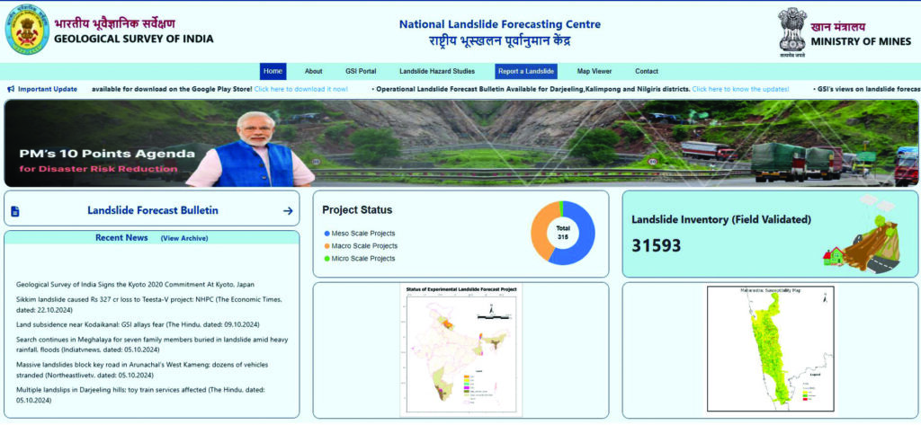
National Landslide Forecasting Centre (NLFC) was inaugurated by the Union Minister of Mines, G. Kishan Reddy, on 19 July 2024 with a collective commitment from the Ministry of Mines and GSI to serve the best in the future for landslide early warning in the country. NLFC has since begun issuing operational daily landslide forecast bulletins for Darjeeling and Kalimpong districts in West Bengal, and the Nilgiris district in Tamil Nadu. Currently, bulletins are being issued for 21 districts across eight States, with 18 at the experimental stage and 3 at the operational stage. The vision is to extend landslide forecasting to all 19 landslide-prone States/UTs by 2030. The first page of the landslide forecast bulletin contains short-term (applicable for 48 hours) and medium-term landslide forecast (for 7 days) information for the district which is updated daily. The second page contains static information to help interpret and understand the forecast. On the day of the centre’s inauguration, GSI successfully operationalised landslide forecasting bulletins for Darjeeling and Kalimpong districts in West Bengal, and Nilgiris district in Tamil Nadu. These three bulletins are available in public domain.
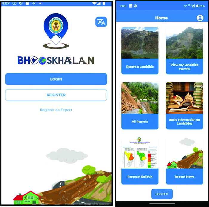
The Bhusanket web portal acts as a single point for providing all landslide reports generated by the nodal agency, the landslide inventory data, the landslide susceptibility map, all relevant and latest news on landslides in the country, and the daily forecast bulletins for the operationalised districts. All the data mentioned above are freely available for all users. To further strengthen the national landslide database, a user-friendly mobile app, ‘Bhooskhalan’ has also been developed for real-time data and to facilitate the sharing of live alerts, and promote community engagement in landslide risk management.
FLOOD FORECASTING
Early warning and flood forecasting systems in India, i.e., C-Flood has been developed by the Central Water Commission under the Ministry of Jalshakti, Government of India. It is an innovative platform delivering accurate and reliable flood forecasts by simulating hydrodynamic processes. It provides inundation spread, water level and village level information (https://inf.cwc.gov.in/). The alert levels are colour-coded, i.e., Yellow indicates predicted water depth below 0.5 m, Orange represents depths between 0.5 m and 1.5 m, and Red indicates depths greater than 1.5 m with at least 40% of the village area inundated.
GLOF FORECASTING
The Central Government has approved National Glacial Lake Outburst Flood (GLOF) Risk Mitigation Project (NGRMP) for its implementation in four states namely, Arunachal Pradesh, Himachal Pradesh, Sikkim and Uttarakhand. NGRMP is aimed at reducing the risks associated with glacial lake outburst floods, particularly in regions that are highly susceptible to such natural disasters and it aims at developing GLOF monitoring and Early Warning Systems (EWS) including remote sensing data, community involvement for monitoring, alerting/ dissemination. Furthermore, a Committee on Disaster Risk Reduction (CoDRR) under National Disaster Management Authority (NDMA) has identified a set of high risk glacial lakes for sending expeditions to directly assess these lakes and prepare comprehensive mitigation strategies in terms of setting up EWS / other structural and non-structural measures.
Centre for Development of Advance Computing (CDAC) has deployed India’s first GLOF Early Warning System for Sikkim to predict GLOFs, which will help the government authorities, in case of an impending GLOF event. This system has capabilities like water level sensors at Shakho Chho Glacial Lake, North Sikkim, the near-real time sensors transmit data through INSAT satellite to control centre at Gangtok, and the flood simulation model runs the simulation for various GLOF scenarios. The model is capable of presenting flood simulation, inundation information and flood arrival time, in the event of a glacier lake outburst flood.
The Government of India has fast tracked its initiatives for building a credible and robust mechanism for disaster risk reduction and also for attaining sustainable development goals as enshrined in the Sendai Framework through development of forecast systems/early warning systems for the common natural disasters noticed in the IHR. The alerts are disseminated to the public as per the Common Alert Protocols (CAP). It is hoped that these efforts will help in realising the sustainable dream of Build Back Better in the IHR and will ameliorate the miseries that the inhabitants have been suffering for long.
*The writer, a Fellow of Geological Society of India (FGS), is Dy Director General (Geotechnical and Geohazard Management) in Geological Survey of India, Central Headquarters Kolkata with a career spanning over 28 years. He is a recipient of prestigious National Geoscience Award 2022 in Applied Geology (Engineering Geology). He was also conferred the Outstanding Personnel of the Year 2017 Award by UJVNL, a power sector undertaking of the Government of Uttarakhand.


