


In India, Master Plans (also referred to as Development Plans) are statutory plans usually prepared by the local or development authority for a future period of 20 years in line with the Town Planning Act of the respective states. Planning for urban areas generally involves addressing many spatial challenges such as urbanisation and its related impacts. These may often comprise the spontaneous growth and proliferation of slums, increasing of air pollution and water contamination, ecological imbalance, traffic congestion, shortage of housing, inadequacy of physical and social infrastructure, etc. Master plans are comprehensive development plans with a focus on improving various sectors such as residential, commercial, recreational, industrial, etc.
The process of master plan preparation primarily includes four stages: (1) Survey and data collection, (2) Analysis and projections, (3) Plan formulation, and (4) Implementation and monitoring. Analysing the past and present trends/ situations/ conditions/ landuse of the urban area or the city and planning for a sustainable future is usually an integral part of any master plan preparation process. In this process, public engagement or consultation is also sought. It most often deals with large databases related to geographic, demographic, socio-economic, environmental aspects, etc., frequently required for the preparation of various cartographic maps including basemaps and landuse maps. Basemaps are usually prepared based on surveys and satellite imagery to show the existing land cover features and administrative layers, i.e., built up area, water bodies, hills, forest cover, contours, greenery, administrative boundaries, etc., falling within the area of interest. Besides, landuse maps are also prepared showing various existing and proposed landuse activity zones like residential, commercial, recreational, public and semi-public, industrial, conservation zones, etc., for the projected population.

Traditionally, these data were collected manually through primary and secondary surveys. In general, these methods of data collation are complex and most frequently time-consuming. Thus, the time taken for preparing a master plan spreads across several years affecting the plan period. However, with the increased technologies, digital or online surveys, instead of physical surveys, are being used. In the past two decades, geospatial systems (remote sensing and geographic information systems) have been extensively used for geospatial mapping and analysis.
GEOAI FOR MASTER PLAN PREPARATION
With the recent rapid technological advancements in the field of Artificial Intelligence, the field of planning is not untouched. These changes have triggered innovative approaches in planning the urban areas using Geospatial Artificial Intelligence (GeoAI), an integration of geospatial systems, machine learning and big data analytics. GeoAI technologies have several advantages and are far more advanced than the conventional urban planning methods. Such technologies can support many sustainable urban planning applications and practices such as water harvesting, smart energy planning, intelligent transport systems, optimisation of waste management, enhancement of disaster management, resilient urban infrastructure, etc. These are now being leveraged in several countries like the USA, the UK and the Netherlands to support urban planning and decision making. For example, in the USA, it is integrated into urban simulation and planning decision-support systems, while in the UK it is being piloted to inform evidence-based land-use and spatial planning decisions at local and strategic levels. The Netherlands uses GeoAI to predict urban flood risks using sensor data and topography to prioritise mitigation strategies. These technologies are not only considered to be transformative but also effective as a decision support system with enhanced accuracy and significant time-saving capabilities.
With GeoAI, geospatial analysis (which is one of the critical aspects of urban planning) has now become relatively much easier than the traditional methods. In general, the cities or the urban areas are dynamic and not static in nature and prone to rapid spontaneous changes due to natural disasters or lack of planned interventions. Monitoring such undue changes in the urban forms or urban morphology is vital for the future sustenance of the city. Continuous real-time monitoring of the city and periodical updation through the integration of GeoAI can considerably reduce a number of urban challenges and complexities. Moreover, it can also be used for geo-processing, enhanced data handling, exploratory analysis, automation of repetitive tasks, support for public participation, situational/real-time awareness and predictive urban scenarios. Broadly, these GeoAI capabilities can be categorised into the following three main strategies for undertaking geospatial analysis: object detection, pattern recognition and pattern prediction. The details of their applications for the preparation of the master plan are as follows:
1. Object detection
a. GeoAI for Basemap Preparation: The object detection capability enables the preparation of basemaps through auto-detection and automated extraction of geographic features with minimal human intervention. Digitisation of satellite imagery manually is a herculean task and is often time-consuming. Therefore, GeoAI can be used for auto digitisation or auto vectorisation (automatic conversion of pixel-based raster data to editable vector features such as points, lines and polygons) of various features such as building roof prints, tree canopy, roads, flyovers, water bodies, major nodes in a city, etc., which in turn can substantially ease the process of basemap preparation. Such tasks can easily be performed using
b. GeoAI for Landuse Map Preparation: Maps showing various landuse activities are vital for any master plan. GeoAI automated satellite image classification leverages machine learning to automatically analyse the imagery of the geographic area under consideration, identify patterns and classify land features useful for the preparation of landuse maps. This process uses spectral information to classify all similar individual pixels. GeoAI based automated image classification reduces time consumption significantly with greater accuracy. The classified image, also referred to a Land Use Land Cover (LULC) map, thus generated acts as a base for the Landuse map.
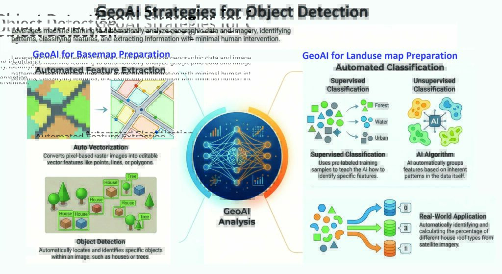
Image Courtesy: Dr Natraj Kranthi
2. Pattern Recognition
a. Density & Proximity Analysis: Master plan usually deals with population density patterns in different zones of the urban area. Due to rapid urbanisation and limited land availability in the urban areas, some areas most frequently tend to develop vertically with high-rise buildings resulting in the increase of population density. This in turn creates pressures on the existing infrastructure, eventually leading to severe shortages. In such cases, it is vital to address the inequitable density growth patterns for a balanced and planned development of the city. GeoAI automated spatial strategies such as Density-Based Clustering can be employed to assess the mass-void or built-green ratios, while Near Analysis can be used to identify the proximity of residential landuse to the road networks.
b. Spatio-Temporal Modeling: Spontaneous growth of settlements such as slums is one of the major urban issues. However, it is most often difficult to recognise such unplanned and random growth of settlements through traditional methods. GeoAI can play an important role in identifying such spontaneously grown urban patterns through automated spatial techniques such as image segmentation and spatio-temporal analysis. Image segmentation converts the satellite imagery into distinct regions of pixels based on visual similarity, while spatio-temporal modeling tracks the change detection or urban evolution on two different timelines. Such analysis can enable the urban planners to have a check on the spontaneous growth of settlements and also can be useful for continuous real-time monitoring. Similar such capabilities of GeoAI can help in the implementation and monitoring of the master plans.
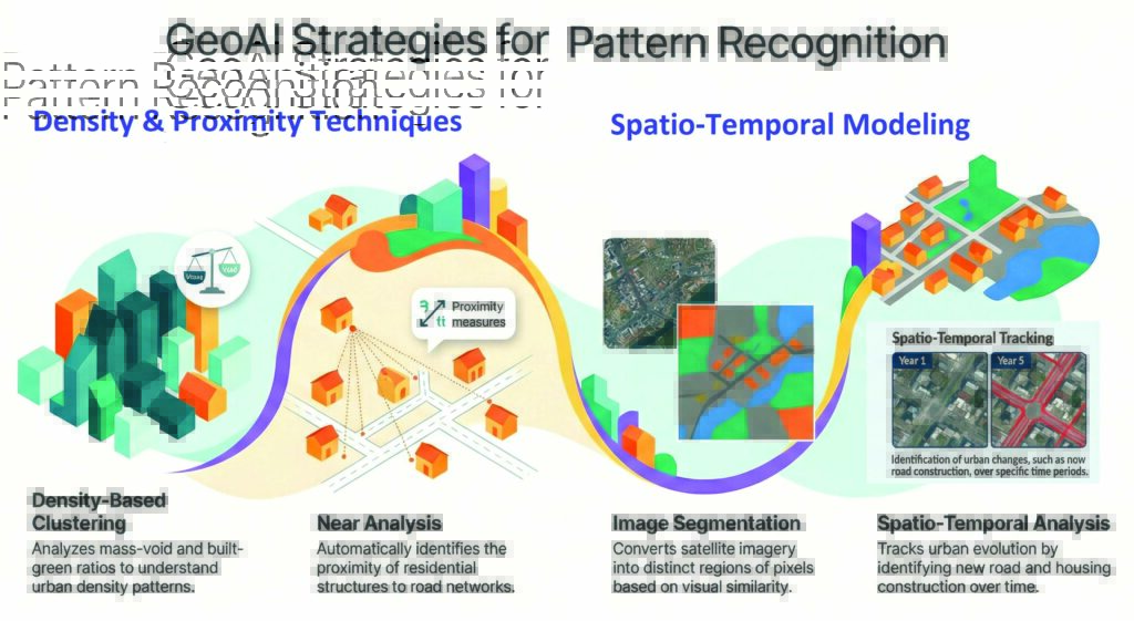
Image Courtesy: Dr Natraj Kranthi
3. Pattern Prediction
a. Predictive Mapping: Based on the study of past urban patterns, future patterns can be predicted through automated GeoAI techniques such as Buffer & Overlay Analysis and Spatial Intelligence to forecast areas for potential development. Such techniques have a wide variety of applications including the identification of the encroachment areas.
b. Automated Population Projections: GeoAI can be useful in streamlining the identification process using automated models for rapid urbanisation patterns and projecting the population for an envisaged period. Further, such automated models can also enable the preparation of proposed landuse maps. Location intelligence, real world awareness and spatial patterns of the automated GeoAI models help in urban pattern predictions with great accuracy.
c. 3D Visualisation: Through GeoAI 3D visualisation capabilities, cities can now be represented in immersive digital twins, enabling urban planners to simulate scenarios, test interventions, and visualise outcomes in a highly accurate 3D environment. By leveraging GeoAI predictive capabilities, visualisation of future cities can improve decision-making, and create more responsive and sustainable urban spaces.
Besides the above strategies, GeoAI can also be used for encouraging people-centric approaches. Community consultation/ participation is one of the critical components of the process of master plan. AI powered geospatial technology can facilitate community engagement, citizen-led data collection, and inclusive decision-making, fostering more informed and equitable planning outcomes. By integrating such technology with grassroots insights, solutions that truly reflect community needs can be created.
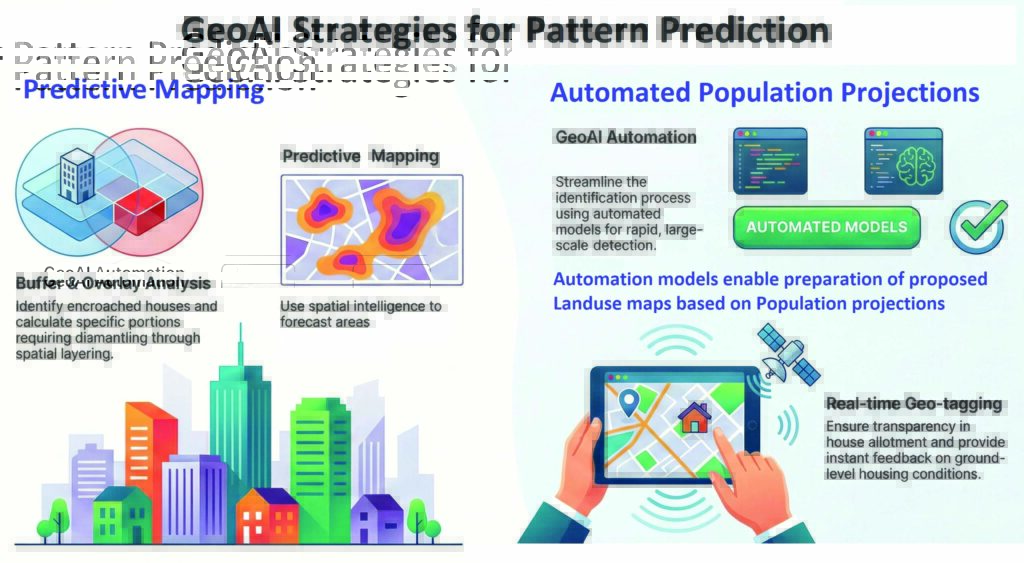
Image Courtesy: Dr Natraj Kranthi
CONCLUSION
For the preparation of master plan, the GeoAI capabilities such as object detection, pattern recognition and pattern prediction can be effectively utilised for enhanced accuracy and substantial saving of time. Through intelligent automation, these capabilities have simplified key tasks like basemap preparation, landuse classification, raster-vector conversion, spatio-temporal detection, and predictive mapping, making master plan more streamlined. Further, they can reduce unwarranted delays in the preparation of master plans and contribute to the timely approval and implementation of the same. GeoAI is not only revolutionising the approach to the preparation of master plans by combining big spatial data but also enabling planners to address complex urban challenges more effectively. Additionally, 3D visualisation of master plans allows the stakeholders to intuitively understand the proposed master plan. This in turn can facilitate communication with the community or the non-technical stakeholders.
Global examples of GeoAI applications in urban planning, particularly for the preparation of the master plan, have reinforced its transformative potential highlighting capabilities as a decision support system. However, to ensure practical and effective implementation of the master plan, it is also important to check the errors and validate GeoAI outputs with the ground realities. To ensure a smooth shift from traditional practices, the transition to GeoAI-powered methods should be gradual and systematic. Besides, it is also crucial to emphasise the ethical considerations to build trust and fairness in GeoAI-driven master plans. Capacity building programmes for town planning officials can enable easier adoption of these emerging technologies. With advancements in GeoAI, intuitive and data-driven master plans can empower cities to become more livable, sustainable, and efficient.
* The writer is a Professor and Head, Centre for Geoinformatics at School of Planning and Architecture, Bhopal.


