


India is a rapidly urbanising nation with nearly 600 million population projected to reside in the towns and cities by 2036. Many urban challenges such as urban sprawl/ unplanned expansion of cities, spontaneous growth of informal settlements, rising levels of pollution, ecological degradation, severe traffic congestion, housing shortages, inadequate infrastructure and inefficient land use patterns, are often a result of such urbanisation. Conventionally, statutory plans such as master plans (also referred to as development plans) are prepared in India to address spatial challenges related with urbanisation and its consequences. Master plans are usually long-term plans prepared for a period of 20 years to guide the sustainable development of cities. However, addressing short-term and real-time changes in cities remains a critical challenge.
Recent studies indicate that the tendency toward unauthorised constructions continues to be increasing in certain forms, even as governments repeatedly try to remove them. Key challenges include unauthorised/ illegal constructions and encroachments, non-conforming to master plans and development control regulations (DCRs) or building byelaws. This in turn disrupts planned structure and the envisaged development of cities, which is particularly evident along the urban roads, rivers, lakes, and in the vicinity of the heritage monuments. Identifying and addressing such encroachments usually involves complex and time-consuming processes. In view of this, there is a need for an urban monitoring system that can complement and support the effective implementation of master plans.
Emerging frameworks like City Information Modelling (CIM) enable real-time monitoring of complex urban systems. It is a digital framework encompassing geospatial systems, Artificial Intelligence (AI), Internet of Things (IoT), Digital Twin (DT), Spatial Data Infrastructure (SDI), and Data Analytics to generate a comprehensive model of a city. It integrates both spatial and non-spatial data; including demographic, socio-economic, environmental and infrastructural information from multiple sources. The concept of CIM is not new and has evolved (in three phases) in the past two decades. The first phase was the data digitisation of physical maps, land records and other relevant documents. The second phase was the integration of diverse data sets within Geographic Information Systems (GIS) platforms. Presently CIM is in its third phase, i.e., intelligent modelling phase and includes emerging technologies such as AI, Machine Learning (ML), IoT, and DT. CIM can be integrated at various scales ranging from a building to an entire city for effective urban monitoring. It is therefore considered as one of the most powerful frameworks, as it enables optimisation of urban systems through continuous monitoring.
DT, an integral part of CIM, can continuously integrate real-time and spatio-temporal data by creating dynamic virtual replicas of the city for smarter urban monitoring. Through this dynamic technology, the exact state of the city can be replicated at any given point of time. Based on this decision support system, urban planners can dynamically monitor critical metrics of urban sprawl and unplanned expansions. Such initiatives are being taken up under the Smart City Mission in India. Presently under this mission, Integrated Command and Control Centers (ICCCs) serve as centralized hubs for data-driven decision making, and real-time monitoring of city services such as traffic, security, water supply, street lighting, waste collection, etc. As these technocratic services have proven to be effective, they can also be extended for monitoring the unplanned urban expansions such as unauthorized, illegal constructions/ encroachments across the city, particularly along the roads, water bodies and monuments. For addressing these challenges, encroachments can be broadly categorized into the following three regulatory buffers i.e., point, line and polygon buffers.
POINT BUFFERS: PROTECTING MONUMENTS & HERITAGE PRECINCTS
As per the Ancient Monuments and Archaeological Sites and Remains (Amendment and Validation) (AMASR), Act 2010, prohibited area extends to a distance of 100 metres in all directions of an ancient monument or an archeological site of national importance. No construction of new buildings, reconstruction or excavation is permissible within this buffer to preserve the monument’s integrity and heritage value. However, a few exceptions can be applicable only with the prior approval of the central government. Further, regulated area extends to a distance of 200 metres beginning at the limit of the prohibited area in all directions i.e., between 100 meters and 300 meters from the monument. In this area, controlled development is allowed under strict regulation with the prior permission of the National Monuments Authority.
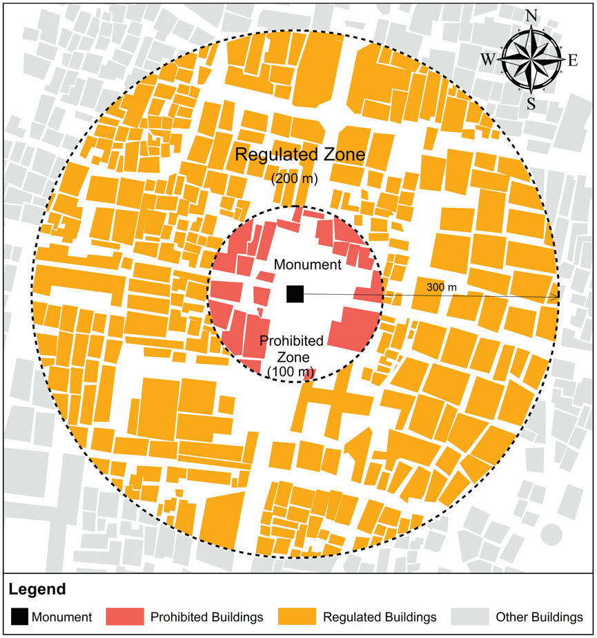
Source: Author
CIM environment has a great potential for continuous digital surveillance of monuments and heritage precincts. Each of the monuments or heritage precincts is georeferenced as a point feature using geospatial components of CIM. Thereafter, circular buffers for both the prohibited (100 metres) and regulated areas (300 metres) from the location of the monument are automatically generated in line with the AMASR Act. Real-time building data derived from satellite imagery or aerial photography or Unmanned Aerial Vehicle (UAV)/ drone surveys are then overlapped onto these buffers. Further, encroachments are identified through the auto-intersection of buffers with any construction falling within the prohibited and regulated areas around the monument or archeological site of heritage value. Finally, those buildings that are constructed beyond the permissible height or number of floors or buildings that are not in accordance with the permissible Floor Area Ratio (FAR)/ Floor Space Index (FSI) as per the applicable DCR are automatically identified. To reduce time consumption, a geospatial technique viz., Model Builder can be utilised to automate and run the above spatial analysis by connecting multiple geospatial operations in a structured sequence.
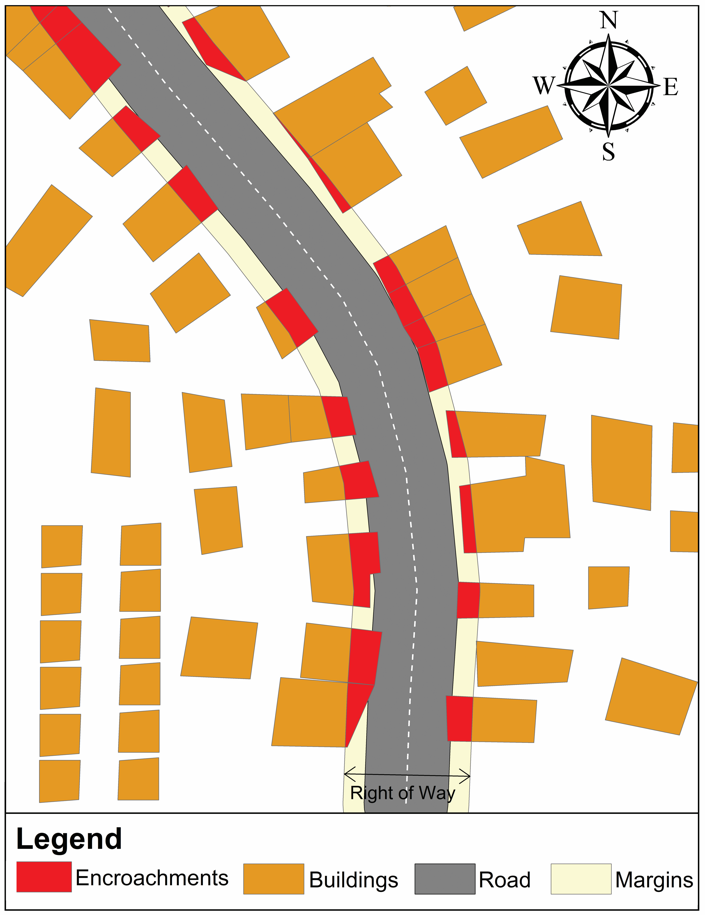
LINE BUFFERS: MONITORING ENCROACHMENTS ALONG THE ROADS
For a smooth urban mobility in Indian cities, strict compliance to the prescribed Right of Way (ROW) standards in line with the applicable provisions of DCRs, Master Plans, National Highways Authority of India (NHAI) guidelines, and relevant state planning laws is essential. In contrast, non-compliance with these standards or regulations often results in encroachments and may attract legal action from the concerned authorities. In general, road encroachments refer to the unauthorised occupation, use or obstruction of public road or its ROW. Such encroachments on roads and public pathways are a major obstacle to achieving sustainable and efficient urban mobility. They are often instrumental in reducing the effective width of the carriage ways thus contributing to traffic congestion, increased travel time, fuel consumption and road accident risk.
CIM can effectively monitor encroachments along roads by integrating geospatial layers, real-time data, and regulatory norms into a single unified platform. Road networks are first mapped as line features. Setback buffers such as statutory ROWs are generated as per the applicable regulatory norms. The buffers thus generated are continuously overlaid with satellite imagery, mobile mapping, UAV surveys or closed-circuit television (CCTV) feeds. Encroachments such as any temporary or permanent construction, illegal parking, street vendors, construction debris, etc., in the road setback buffer can be identified through automated spatial analysis. Geospatial artificial (GeoAI) intelligence can provide many features for such automated spatial analysis. The dynamic nature of CIM enables real-time and spatio-temporal monitoring of the roads and can help in flagging recurring violations. Additionally, 3D visualisation replicas through digital twins can trace vertical intrusions such as hoardings, sign boards, over handing structures, etc. Such monitoring can allow the planning authorities to prioritise critical corridors and plan for targeted clearance drives based on real usage patterns.
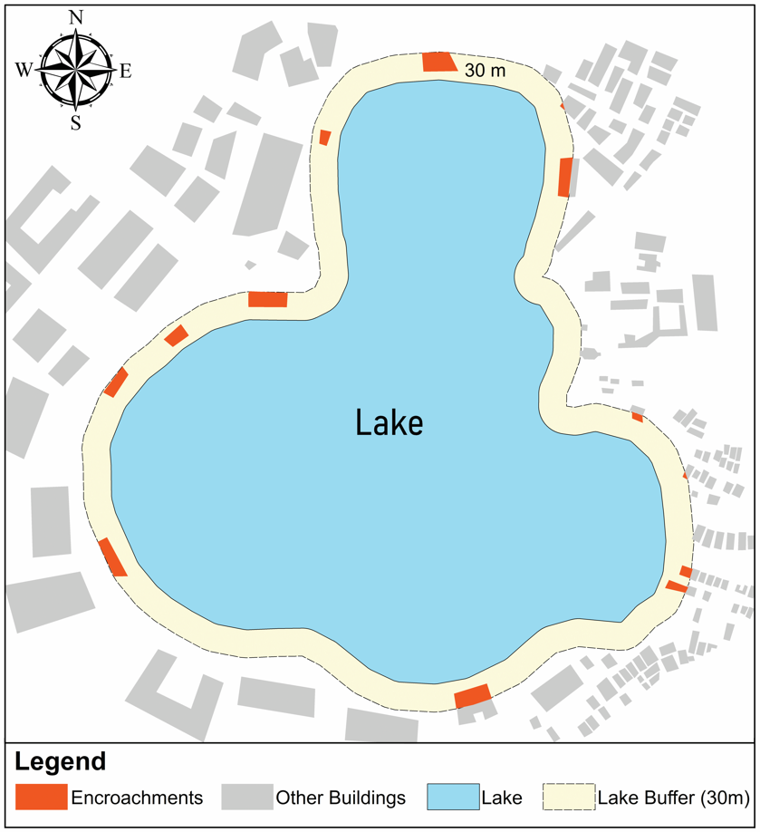
POLYGON BUFFERS: SAFEGUARDING WATER BODIES AND ECO-SENSITIVE ZONES
In India, Wetlands (Conservation and Management) Rules, 2017 is a notified framework under the provisions of the Environment (Protection) Act, 1986 for the conservation and management of wetlands. These rules also guide and support the State Governments / Union Territory (UT) administrations to conserve, manage, and maintain the ecological character of wetlands while promoting their wise use. In contrast, the protection and regulation of water bodies such as lakes is primarily the responsibility of state governments, implemented through state-level planning, regulatory, and administrative authorities. The Lake Protection Committee of Hyderabad Metropolitan Development Authority (HMDA) is one such example. It notifies the Full Tank Level (FTL) boundaries and buffer zones of lakes or water bodies falling within its region, to maintain recreational or green buffer zones, while restricting any building activity. A buffer of 30 metres is mandated for lakes larger than 10 hectares, while a buffer of 9 metres is prescribed for lakes smaller than 10 hectares.
Urban lakes are digitally mapped as polygon features within CIM. Buffer zones are created around the lakes in line with the applicable eco-sensitive zones or lake protection regulations as mentioned above. Such buffers are critical to maintain hydrological balance and to prevent pollution of the lake thereby protecting its biodiversity. These buffers are further overlapped with landuse data and building footprints, allowing the CIM to detect and flag the encroachments such as construction, dumping or land reclamation in the prescribed lake buffer. Additionally, CIM framework can also virtually simulate such encroachments, demonstrating how reduction in the buffer can increase flood risk disrupting the natural drainage. As a dynamic system, CIM can monitor spatio-temporal encroachments through real-time data feeds rather than merely capturing static violations. This in turn can enable timely intervention before any occurrence of irreversible damage.
RECOMMENDATIONS
Encroachments along roads, water bodies, and heritage monuments often pose a threat to sustainable urban development. They most frequently lead to inefficient land uses, mobility constraints, environmental degradation, and loss of cultural assets. In order to address such issues, the following integrated approach of CIM is recommended for a smarter urban monitoring:
- CIM integration with Master Plans: Master plans should be integrated with the GeoAI enabled Digital Twins. Various landuse zones and infrastructure networks coupled with regulatory layers should be generated and automated with CIM environment. Such an environment enables continuous data updation through real-time data feeds and data validation against real-world developments. Besides, master plans should incorporate a feedback loop mechanism, where detected violations and spatial changes automatically can update the planning database.
- CIM integration with Regulations: Relevant and applicable regulatory provisions should be encoded as machine-readable rules to allow automated detection of violations. Such provisions may include permissible setbacks, FSI/ FAR, RoW, buffer zones for roads, water bodies, and heritage structures from Master Plans, DCRs, Town and Country Planning Acts, Urban and Regional Development Plans Formulation and Implementation (URDPFI) guidelines, and any other orders / guidelines by concerned government authorities from time-to-time.
- CIM integration with DT: For ensuring continuous monitoring of urban expansion and landuse changes, CIM platforms should be integrated with digital twins. This may include multi-source real-time data streams such as satellite imagery, aerial photography, UAV surveys, CCTV networks, IoT sensors, etc., enabling generation of 3D digital replicas of the real world.
- CIM integration with SDI: A centralised SDI should be created to integrate relevant datasets from the urban local bodies, planning authorities, and other concerned departments. This will enable easy access to available data within CIM environment, thereby contributing to significant time savings, improved data consistency, and reduced data duplication.
CONCLUSION
Integration of CIM with the master plans, regulatory provisions, digital twin technology, GeoAI and spatial data infrastructure can significantly strengthen urban monitoring. Such integration can transform traditional systems into dynamic and data-driven decision systems. Also, planning authorities can considerably improve identification, monitoring, and management of illegal constructions through systematic and automated processes. By adopting above steps within a CIM environment, any new construction falling within the restricted buffer in and around heritage monuments, water bodies or roads can be instantly flagged as being in contravention. Beyond conventional 2D mapping, CIM also enables advanced 3D visualisation allowing urban planners to evaluate not only horizontal encroachments but also vertical violations. This power of CIM can transform the urban monitoring of cities from periodic inspections into smarter digital monitoring, improving transparency, and long-term urban sustainability.
*The writer is Professor and Head, Centre for Geoinformatics, School of Planning and Architecture, Bhopal.


