





Images Courtesy: Twitter
On the morning of August 26, 2026, massive flash floods on the Nepal-Tibet border wreaked an unprecedented catastrophe, the consequences of which will take a long time for the Himalayan country to recover from.
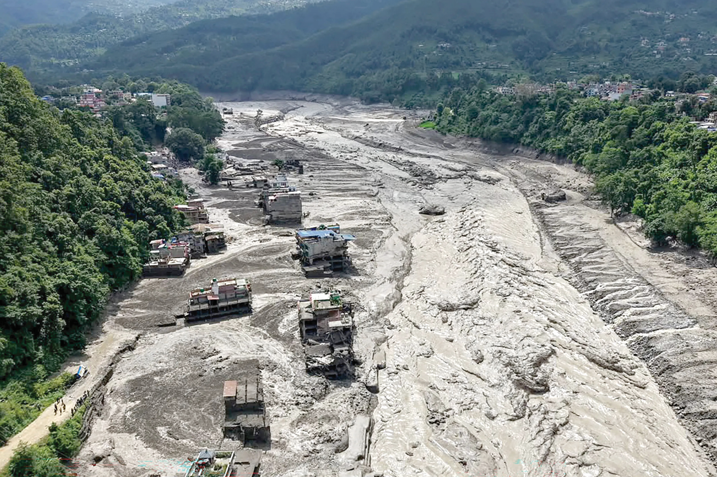
On August 26, a massive failure involving ice, rock and mountain slope material in the Langtang region of Nepal unleashed a violent cascade into the Lhende Khola, a high altitude river near the Nepal-Tibet border, which feeds as a tributary into the Bhotekoshi river. The resulting torrent travelled almost 100 kilometres downstream, gathering enormous quantities of rock, sediment, mud and debris as it descended. By the time it reached inhabited valleys, hydropower installations and the strategic Rasuwagadhi border crossing, it was no longer simply a flash flood. It had become a rapidly moving wall of water and mountain debris.
The consequences have been catastrophic. Nearly a thousand people have died and many thousands more are missing. Hundreds of people also remain unaccounted for at hydropower projects, many of them believed to be trapped inside tunnels.
THE CONSEQUENCES AND FALLOUT
The disaster has also exposed the extraordinary vulnerability of the Himalayan development corridor. Roads, bridges, settlements and hydropower projects were swept away or buried beneath tonnes of sediment. Preliminary estimates put the quantity of debris generated by the disaster at about 2.2 million tonnes. Nepal’s property and infrastructure losses alone have been estimated at approximately $2.56 billion, while thousands of homes have been destroyed or rendered uninhabitable.
The hydropower sector has suffered particularly badly. At least 12 projects were affected, and the disaster is estimated to have disrupted around 10 per cent of Nepal’s power-generation capacity. About 900 people may have been working in or around tunnels connected with six hydropower projects when the flood struck. The tragedy has therefore become not only a humanitarian emergency but also a profound question about the country’s model of infrastructure development in one of the world’s most geologically unstable environments.
Nepal faces the rebuilding of thousands of homes, roads and bridges, the restoration of electricity and communications, prolonged searches for missing people, and the psychological trauma of communities that have lost family members and livelihoods; cross-border trade through the Nepal-China corridor has been disrupted.
WHAT ACTUALLY HAPPENED ON THE MOUNTAIN?
The first explanations were uncertain. There was speculation about an earthquake, a glacial lake outburst flood (GLOF), intense rainfall and other possible triggers. Satellite imagery and subsequent scientific analysis have considerably narrowed the possibilities.
The US Geological Survey describes the event as a catastrophic debris flow and flood probably triggered by a rapid slope failure involving a glacier in Langtang National Park, near the Chinese border. The material then entered the Lhende Khola and travelled downstream before reaching the Trishuli river system.
This distinction is important because the disaster has sometimes been described as a glacial lake outburst flood, or GLOF, which occurs when water stored behind or within a glacial lake is suddenly released. Nepal and the wider Hindu Kush-Himalayan region have experienced several such events, and they are an increasing concern as glaciers retreat and glacial lakes expand.
But the August 26 catastrophe appears to have been different.
According to the International Centre for Integrated Mountain Development (ICIMOD), the immediate trigger was an ice avalanche, rather than a conventional GLOF. In other words, the initial event was the collapse or rapid failure of a mass of ice and rock, rather than the simple breaching of a lake containing glacial meltwater.
That distinction also helps explain the extraordinary destructive power of the flood.
Imagine a block of ice and rock suddenly collapsing down a steep Himalayan slope. Gravity accelerates the mass as it descends. It breaks apart, pulverises rock and snow, and interacts with whatever water is present. Once it reaches a river valley, it can entrain enormous quantities of loose sediment. The river effectively becomes a conveyor belt for a mixture of water, boulders, gravel, mud, ice and broken mountain material.
This is known as a debris flow or debris-laden flood. Its destructive capacity is vastly greater than that of water alone.
Water can inundate a building. A debris flow can hit it with boulders, bury it in sediment and physically scour away its foundations.
The topography of the Himalaya amplifies this effect. The mountains are exceptionally steep, the valleys are narrow and rivers are confined between enormous walls of rock. A sudden release of material therefore has little opportunity to disperse. Instead, it is funnelled downstream, gaining speed and destructive momentum.
The USGS estimates that the August event travelled almost 100 kilometres, demonstrating how an apparently local failure high in the mountains can become a disaster across an entire river system.
There is another crucial scientific element: the Himalaya is not a static landscape.
It is one of the youngest and most tectonically active mountain systems on Earth. The Indian and Eurasian tectonic plates continue to converge, constantly deforming and fracturing the landscape. Earthquakes, landslides, rockfalls and slope failures are therefore intrinsic features of Himalayan geology.
At the same time, the region’s glaciers and permafrost are changing rapidly.
A warmer climate does not mean that every Himalayan flood can automatically be labelled a consequence of climate change. Scientists at ICIMOD have specifically cautioned against making such a direct attribution for this individual event. The immediate trigger here was a physical slope failure involving ice and rock, and the precise chain of events leading to that failure remains a subject of scientific investigation.
Yet the broader climate connection is difficult to ignore.
Warming alters the cryosphere— the frozen component of the Earth system comprising glaciers, snow and permafrost. Glacier retreat can destabilise slopes; melting ice can change the distribution of water within mountain systems; and thawing permafrost can weaken material that previously acted as a kind of frozen cement binding rock and sediment together.
These processes do not mean that a particular glacier must collapse because of warming. Rather, they can alter the background conditions in which mountain hazards occur.
And the hazard is becoming more complicated because several processes can interact.
A glacier can retreat. A lake can grow. A slope can become unstable. Heavy rainfall can saturate loose material. An avalanche can enter a river. The river can then entrain more sediment, transforming a relatively small initial disturbance into a massive downstream flow.
This phenomenon is sometimes described as a cascading hazard: one mountain process triggers another, which triggers another, with each stage magnifying the consequences.
That is perhaps the most important lesson of the Nepal disaster.
The same river systems that provide enormous potential for electricity generation also provide the pathways through which water, ice and sediment can move at terrifying speed.
The question after August 26, therefore, is whether the Himalayan countries can learn to anticipate a new generation of compound mountain disasters—events in which glacier, geology, water and human infrastructure interact in ways that traditional flood-warning systems were never designed to predict.
The tragedy on the Nepal-Tibet border was born high above the settlements that suffered its consequences. A failure on a remote Himalayan slope travelled down a river, gathered the mountain into itself, and transformed a natural process into a human catastrophe.